

Building In-house GIS Services
Including
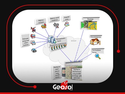
Design, Implementation, integration, and Customization of Geocoding/ Reverse Geocoding services with support of Different UTF-8 and RTL Languages (English and Arabic are fully supported) based on our GIS data or any other third-party data, with performance tailored and optimized for each specific application and country culture. Design, Implementation, integration, and styling of MAP Services, either Dynamic or Static. Design, Implementation, and integration of Network Services (finding the best route) based on static or dynamic (Live Traffic), when supported. Implementation of search and image services. Providing spatial analysis services to help in forecasting and prediction of geographically affected crises (pandemics, earthquakes, weather changes…etc) that help in proactive actions and save lives, based on historical, and current Live data.
Building GIS Applications
Building Customized turnkey systems that emphasize the power of GIS systems and make the best use of them, such as CAD and AVL systems, Including
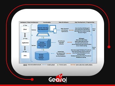
-The installation, configuration of, and integration with edge IOT Devices and/or Telematics hardware. The Server infrastructure systems and hosting of the GIS services.
-Providing and maintaining a reliable connection between the edge devices and sensors on one hand, and the system services on the other hand. Any required ready or customized software API.